STUDIO
CORE I: SURFACE, EDGE, INDETERMINACY
SITE
SEAPORT DISTRICT, BOSTON, MA, USA
INSTRUCTORS
ZANETA HONG, GARY HILDERBRAND
TERM
FALL 2015
Transpose, Transform
Students first transposed elements derived from an assigned precedent onto the site. Then, through an iterative process of abstraction and transformation, new designs aimed to choreograph Boston's tidal fluctuation into a unique harborfront experience with access to water.
A New Language for a New Place
The seaport district is a massive, high-profile conversion of a post-industrial waterfront into a convention center and innovation district. Its growing pains include the ongoing struggle of creating a new neighborhood and sense of place in the context of large office towers and speculative condominiums. Emboldened by the adjacent Institute of Contemporary Arts, the waterfront plaza design embraces this freedom to develop a new formal language while grounding itself in relation to the museum and the materiality of the harborfront's rip-rap edge.
STUDIO
CORE II: INSIDE-OUT, OUTSIDE-IN
SITE
FRANKLIN PARK, BOSTON, MA, USA
INSTRUCTOR
SILVIA BENEDITO
TERM
SPRING 2016
Olmsted’s Plan: The Greeting
The “jewel” of the Emerald Necklace, Olmsted’s 527-acre Franklin Park was originally designed in 1885 to be a “Country Park”, a metropolitan destination for respite and the experience of a rural landscape. Its formal entry and most notable feature, The Greeting, was drawn as a half-mile-long, linear promenade for recreational driving, riding, and strolling. What was built instead, however, reflected the trends of the time. A golf course replaced Olmsted’s countryside, as did a stadium and the Franklin Park Zoo, dramatically reducing public access and use.
Remixed: An Active Edge
In this project, the Greeting is reintroduced as a thickened, activated edge that responds to the park’s urban context and topography. Parallel allées wind around the site’s unique rock formations and hills, amplifying site features, framing views, and creating a variety of layered spaces that invite the city into the park’s vast interior.
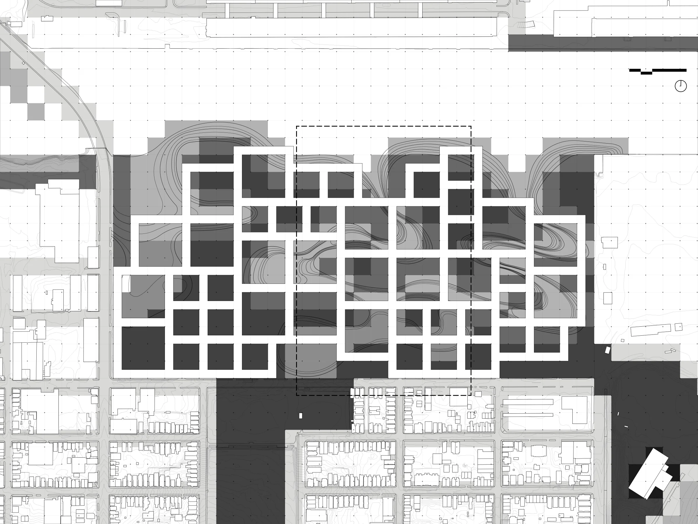
STUDIO
CORE III: THE ADAPTIVE CITY
SITE
RESERVE CHANNEL, BOSTON, MA, USA
INSTRUCTOR
FIONN BYRNE
COLLABORATOR
CATHERINE KEUNG, MLA II
TERM
FALL 2016
Landscape Parametricism
Core III focused on technological experimentation in rapid prototyping: landform generation, modeling, and simulation at the urban scale. Grasshopper, CNC milling, and a geomorphology table drove the studio’s “landscape first” approach to city making.
The Adaptive City
The studio aimed to conceptualize an “Adaptive City” that could accommodate ever-evolving environmental, programmatic, market, and sociocultural conditions. To this end, our project imagined an urbanism in the form of an elevated, collective mat of re-configurable units. Acting as a cohesive organism, the mat would be in dialogue with its environment, continually assessing and evolving its urban pressures and programming in relation to land, hydrology, flora and fauna through strategic modifications in footprint, density, height, porosity, aspect, materials, etc. Instead of today’s urbanism shaped by streets and cars, we asked, “What if nature took the lead? What might that stewardship look like?”
STUDIO
CORE IV: TERRITORIAL ECOLOGIES
SITE
CLARK AIR BASE, ANGELES, R.O. THE PHILIPPINES
INSTRUCTOR
ROBERT PIETRUSKO
COLLABORATOR
EMILY DRURY, MLA I
TERM
SPRING 2017
Territorial Ecologies
Core IV sought to investigate the role of ecological processes in complex urban landscapes. Through the medium of mapping and a variety of immersive respresentation methods (in our case, an animated video), students were tasked with framing narratives and counter-narratives to produce speculative, landscape-based design strategies and spatial interventions.
Colonialism, Globalization, and Disaster
Clark Air Base is a site fraught with issues of colonial oppression, military occupation, toxic waste dumping, volcanic and typhoon-related disasters, economic dependency, illegal resource extraction, corruption, and large-scale, logistics-based redevelopment strategies in the form of Special Economic Zones (SEZ). Our research as a studio section focused on the potential empowerment of indigenous tribes caught in this mix and that stand to continue to experience the worst of the consequences.
Geological Time, Risk, and Marginalization
At the crux of our narrative is the contested territory between Ancestral Domain Titles and encroaching, state-sanctioned land grabs for the growing Clark Freeport and Special Economic Zone. Through our research, we learned that CADTs correspond closely with previously assessed “Danger Zones” and appear to be valid only at the discretion of corporations, their economic interests, and their tolerances for environmental risk.
Subverting the Cost-Benefit Analysis
Recognizing that marginalized, indigenous tribes have for centuries lived resiliently in territories of risk– now their ancestral homes- our narrative imagines the operationalization of these territories of risk and the subversion of risk assessment and subsequent cost-benefit analyses in the interest of protecting and even expanding indigenous territories against the threats of eminent domain, in which tribes are powerless against the law.
STUDIO
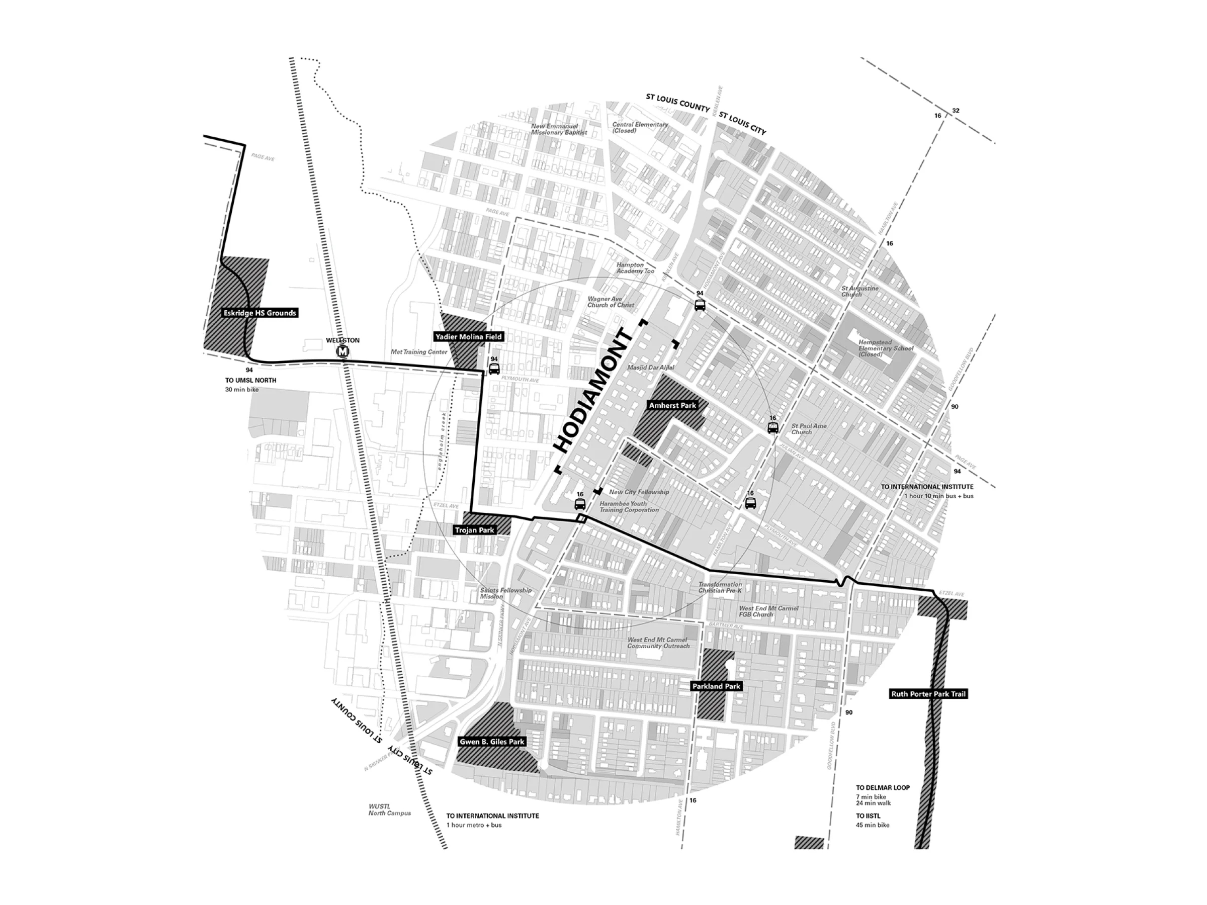
REFUGEES IN THE RUST BELT (UP)
SITES
ST. LOUIS, MO / DETROIT, MI / CLEVELAND, OH / AKRON, OH, USA
INSTRUCTOR
DAN D'OCA
SPONSOR
THE TENT PARTNERSHIP
COLLABORATOR
JOHN WAGNER, MARCH II
TERM
FALL 2017
Making Heimat (“Homeland”) / Arrival City
Making Heimat is an exhibition by the Deutsches Architekturmuseum (DAM) in consultation with Doug Saunders– author of Arrival City– in response to the over-a-million refugees that entered Germany in 2015 and 2016. The 8 theses developed in the exhibition served as the basis for the studio in formulating design concepts that aspire to make cities more welcoming and helpful to refugees and immigrants.
Refugees in the Rustbelt
Interviews with refugee resettlement agencies, non-profits, artists, faith-based and community development organizations, city offices, and refugees in St. Louis, Detroit, Cleveland, and Akron helped to situate our ideas in the context of the American Rustbelt.
Affordability, Distance, Time, and Alienation
Common assumptions for why refugee resettlement is beneficial for both refugees and Rust Belt cities include: the availability of vacant land and housing, the need to increase the tax base, affordability, and the entrepreneurial qualities of refugees. On the other hand, some major challenges that our project attempts to take on are: the distance between agency services and affordable housing, inadequate/stigmatized public transportation, the need for basic services in disinvested (black) communities, untapped neighborly support networks, and the invisibility of the refugee resettlement process that can perpetuate “othering”, alienation, and conflict.
Co-Beneficial Mobile Services /
Plugging In: A Dynamic Civic Commons
Our project proposes mobile services that– with other kinds of mobile programming like food trucks, markets, pop-up events, community outreach, etc.– can plug in to designated public spaces and be accessible to all. The scenario imagines upward mobility and integration for refugees and citizens alike becoming an active, communal process that is systematized and normalized as a part of everyday public life.
STUDIO
ECOLOGY, CULTURE, IDENTITY: REVITALIZING THE HUERTA (LA/UP)
SITE
VALENCIA, GENERALITAT VALENCIANA, SPAIN
INSTRUCTOR
ARANCHA MUÑOZ-CRIADO
SPONSOR
THE AGA KHAN PROGRAM
COLLABORATOR
JILL SCHMIDT, MUP
TERM
SPRING 2018
Green Infrastructure and The Huerta /
A Complex, Cultural Landscape
Arancha Muñoz-Criado, the studio’s instructor and former Director of Urban Planning, Landscape, and Environment for Valencia, Spain has built her career on implementing green infrastructure frameworks, including the recently passed Landscape Protection Law (2018) for the cultural landscape of The Huerta– which refers to Valencia’s traditional agricultural lands that are irrigated by the River Turia through a complex system of dams and acequias established by the Moors and managed to this day by an ancient Water Court considered to be the oldest democratic body in Europe. Its continued survival in modern times, however, faces many challenges– of ecological, cultural, economic, and political natures– and the nuanced debate between the different factions in Valencia over the consequences of the Huerta’s preservation will be long and ongoing. Our project recognizes this complexity and indeterminacy, and seeks to bring new possibilities to the root of the conversation: Valencians’ relationship to water and the River Turia– the source of their cultural mythology, economic history, and focus for climate change considerations moving forward.
Dammed: Irrigation and Flood Control
Known as the “Perla del Turia,” Valencia is a city that has evolved with its river since its founding by the Romans in 138 BC. In 1957, however, after a devastating flood resulted in 81 deaths and flood waters rose to 5 meters high in the streets, the government decided to effectively cut the Turia River off. Plan Sur began the operation in 1964 with the installation of a new dam to provide irrigation water and the construction of “Nuevo Cauce”, a concrete and rock flood channel situated to the south of the city and running through the South Huerta. At 12 kilometers long and up to 200 meters wide, the new channel was a technocratic solution that came at great ecological and social cost. Lined on either side with major highways connected to Valencia’s port, the industrial corridor is a dead zone in the city and a vast barrier between the city and its south.
Reclaiming Public Domain
While this massive infrastructural project is typically touted as a positive origin story for the wildly successful Turia River Garden– the 9-kilometer-long linear park in the former Turia riverbed– attention has been turning to the Nuevo Cauce itself. Designated officially by the government as “Public Domain”, its use as such is now being considered by the Valencian public. This project puts forth a vision for the Nuevo Cauce as a new kind of River Turia: an accessible public amenity that physically connects the City of Valencia and the South Huerta with bike and pedestrian access, establishes a new cultural relationship between the city and the complex realities of its diminished river, and provides a strong connection between the region’s four major, interrelated landscapes– Turia Nature Reserve, the Albufera, the Mediterranean Sea, and the Huerta– within the larger framework of the city’s green infrastructure plan.
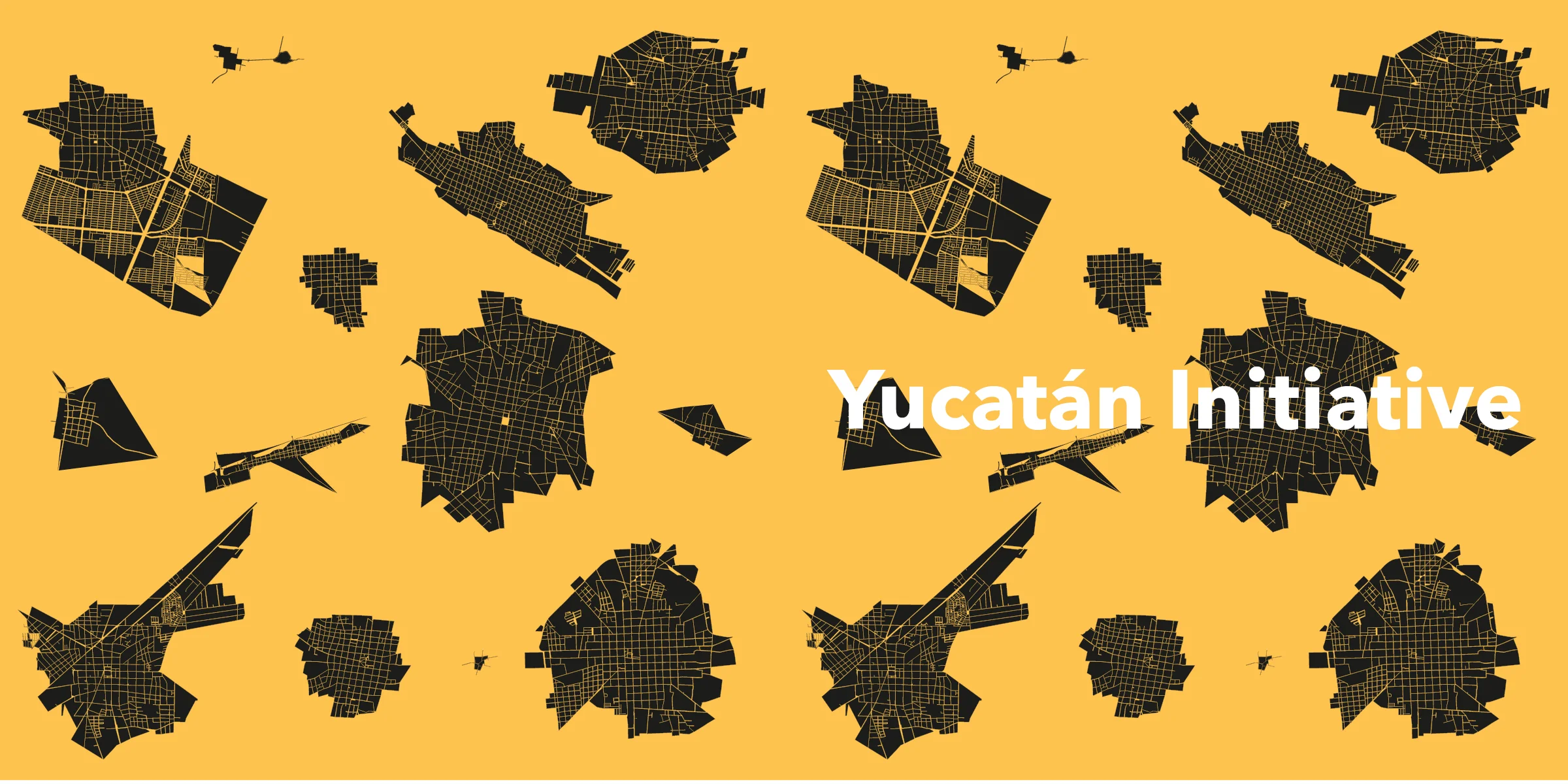
RESEARCH FELLOWSHIP
SITE
YUCATÁN, MEXICO
ADVISORS
JOSE CASTILLO, DIANE DAVIS
SPONSORS
BAKTÚN ALLIANCE (UNIVERSIDAD MARISTA, INAH, TRANSFORMACIÓN ARTE Y EDUCACIÓN), INFONAVIT, AND UNESCO
GSD TEAMMATES
ALEJANDRO FERNÁNDEZ-LINARES GARCÍA, MARCH II; ALEX DUFFY, MDES ULE; ALICE ARMSTRONG, MARCH I; ARIANNA GALÁN, MARCH I; MARYSOL RIVAS BRITO, MARCH II
DATES
JUNE 2016 - JAN. 2017
Cultural Patrimony in the Built Environment
In the context of rapid urbanization and globalization, the Mayan cultures found in the pueblos across the Yucatán peninsula face many challenges. It was our charge, through extensive field studies across more than 18 pueblos and cities, to assess the current conditions of the built environment as it relates to cultural conservation and to identify potential strategies for responsible and sustainable urban growth. In the process, we initiated the production of a publication to document the current state of urbanization and to inform and mobilize stakeholders and communities on the importance of the built environment in conserving their cultural practices, values, relationships, landscapes, aesthetics, etc. Through our fieldwork, we put pueblos on the map (Google maps) and further developed– with INFONAVIT– an online geospatial platform for open source use. Local residents and stakeholders can continue to share and contribute data, knowledge, and photographs to the project.
PROFESSIONAL WORK
POSITION
ARCHITECTURAL PROJECT DESIGNER
PRINCIPALS
HEATHER WOOFTER, SUNG HO KIM
TEAM
VARIOUS
DATES
SEPT 2012-OCT 2012, JAN 2014-JUN 2015
Design, drawing, rendering; digital fabrication, and model-making for exhibition and publication.